|
Bale
Mountains
National Park
is an area of high altitude plateau that is broken by numerous spectacular
volcanic plugs and peaks, beautiful alpine lakes and rushing mountain
streams that descend into deep rocky gorges on their way to the lowlands
below. As you ascend into the mountains you will experience changes in the
vegetation with altitude, from juniper forests to heather moorlands and
alpine meadows, which at various times of year exhibit an abundance of
colourful wildflowers.
Bale Mountains
National Park is the largest area of Afro-Alpine habitat in the whole of
the continent. It gives the visitor opportunities for unsurpassed mountain
walking, horse trekking, scenic driving and the chances to view many of
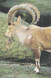
Ethiopia's endemic mammals, in particular the Mountain Nyala and Semien
Fox, and birds, such as the Thick-billed Raven, Wattled Ibis, Blue-winged
Goose, and Rouget's Rail.
Topography
The Bale Mountains rise from the extensive surrounding farmlands at 2,500
m above sea level to the west, north and east. The National Park area is
divided into two major parts by the spectacular Harenna escarpment that
runs from east to west.
North of this escarpment is a high altitude plateau area at 4,000 m
altitude. The plateau is formed of ancient volcanic rocks (trachytes,
basalts, agglomerates and tuffs) dissected by many Rivers and streams that
have cut deep gorges into the edges over the centuries. In some places
this has resulted in scenic waterfalls. From the plateau rise several
mountain massifs of rounded and craggy peaks, including Tullu Deemtu the
second-highest mountain in
Ethiopia at 4,377 m above
sea level. (Ras Dashen, near the
Simien
Mountains
National Park
in the north is the highest - 4,543 m). A major part of the central peaks
area is covered by a capping of more recent lava flows, still mainly
unvegetated, and forming spectacular rock ripples and pillars. Many
shallow depressions on the plateau are filled with water in the wet
season, forming small lakes that mirror the surrounding scenery. Larger
lakes such as Garba Guracha ("black water"), Hora Bachay and Hala Weoz,
contain water all year round. These many lakes provide habitat for water
birds, especially migrating ducks from Europe during the northern winter.
Best time to visit
The climate of the
Bale
Mountains,
as is to be expected in a high altitude mountainous region, is
characterized by a high rainfall and periods of damp cloudy weather,
interspersed with periods of sparkling sunny weather with brilliant blue
skies.
The climatic year can be roughly divided into three seasons -the dry,
early wet and wet seasons. The dry season is usually from November to
February. Very little rain is experienced and temperatures on the clear
sunny days may rise to as high as nearly 30° centigrade. Nights are
star-filled, clear and cold, usually with heavy ground frosts.
Temperatures may fall between minus 6° and minus 15° centigrade in the
main peak area of the Park. This is the best period to visit the National
Park, especially for walking and horse trekking in the high mountain area.
The vegetation can get very dry in the dry season, and fires must then be
very carefully tended.
The early wet season lasts from March to June, and about two-thirds as
much rain falls in this period, as in the wet season from July to October.
Throughout these eight months, days are generally cooler and nights warmer
than in the dry season. Despite the wetter weather, the area can still be
enjoyed with adequate warm and weatherproof clothing. Bright sunny periods
may be experienced at any time. Snow has been recorded, but does not lie
around for very long.
South of the
Harenna escarpment, the land falls precipitously to a large area of
dense Podocarpus forest, that slopes gradually down to an altitude of 1
500 m at the southern Park boundary. A few kilometres further on the land changes.abruptly to open wooded grasslands, with higher temperatures and
the surprising sight of camels in the area of Dolo-Mena.
Vegetation
The high rainfall in the
Bale Mountains, together
with the great variation in altitude and topography, result in rich
diversity in the vegetation. Changes in the vegetation with altitude are
clearly seen, this zonation being a result of increasing then decreasing
rainfall as you ascend, generally decreasing temperatures, and increased
exposure of rock and resulting poorer soils.
The mountains are surrounded to the northwest and northeast by fertile
plains at 2,500 m that are heavily utilized for agriculture mainly wheat
growing. This is succeeded by remnants of beautiful juniper and Kosso (Hagenia
abyssinica) forest -a belt that reaches up to about 3,300 m altitude,
which is the upper limit of the tree zone, apart from a few isolated trees
in protected valleys. Above the tree line the heather moorlands begin,
reaching to about 3,600 m altitudes on gently sloping ground, and as high
as 3,800 m on steep rocky slopes. Above this are various forms of
Afro-Alpine moorland, dominated by different plants depending on slope,
drainage and rodent activity. The tops of most of the high peaks are
either bare rocks, or exposed soil with very small hardy tussock herbs or
grasses. To the south, the land falls away far more, through rich and
varied forest below the heather, containing bamboo and giant Podocarpus
trees, and finally giving way to dry short-tree wooded grasslands at 1,600
m on the southern boundary of the Park.
The northern forests are open with little under-growth, and while
dominated by Juniper and Hagenia trees, also contain St John's Wort and
bushes (Hypericum spp.) with large golden-yellow flowers, Schefflera
abyssinica and Rappanea simensis trees amongst others. The grassy forest
floor makes for easy walking and viewing of animals; the wonderful fruity
smell of fallen Hagenia leaves rising from your path. This large tree of
the rose family, has separate male and female trees; the female flowers
contain anthelmintic, and are widely used in a decoction against the
tapeworm. Another member of the rose family - Rosa abyssinica is found
here, with its beautiful white flowers and delicate scent, the only
indigenous African rose.
The southern forests, in contrast, are much denser with a greater variety
of tree, shrub and herb species. Juniper is not found on the south side,
but the other species are. The trees are covered in epiphytes and
creepers, and in many cases rise to over thirty metres in height. Higher
reaches of the forests, near Katcha at 2,600 m, are interspersed with
bamboo groves, and many wildflowers beside the small rushing torrents.
Early in the wet season, dense thickets of edible Rubus steudneri in the
blackberry family are in flower and fruit. Streamside beds of the
white-flowered Crinum ornatum with their heavy sweet scent also bloom at
this time. Occasional grassy glades occur mainly where drainage is poor
and small swamps form along River and stream courses.
Vegetaion
Grassland has formed at the forest altitude near Dinsho and at Gaysay.
This is partly due to the action of man, but mainly at Gaysay through
impeded drainage and marshy conditions. These grasslands include large
areas of the scrubby aromatic "sagebrush " plant (Artemesia afra) -a
staple foodplant of the Mountain Nyala, and the grey-green leaved
"everlasting" flower (Helichrysum splendidum), which produces papery
bright yellow flowers early in the wet season at this altitude. The
heather zone is often burnt in an attempt by pastoralists to obtain more
grassland. As a result the size of the heather (mainly Erica arborea)
varies greatly -from thirty centimetre recent regrowth to five metre tall
mature trees. Mature heather trunks and stems are usually lichen and moss
covered and the frequent mists also support a lush dense growth beneath
them of wildflowers and grasses.
The Afro-Alpine moorlands and meadows are mainly dominated by low (50 cm)
scrubby vegetation of either the "everlasting" flower genus (Helichrysum)
or by Alchemilla johnstoni. Within and above the heather zone, these
plants may form a continuous dense ground cover, but with increasing
altitude they are reduced to tussocks with bare soil and grass clumps in
between. Alchemilla predominates in wetter situations along drainage
lines, while various Helichrym species dominate in flatter areas and at
higher altitudes. There are more than ten different species of
"everlasting" flower in the mountains -so- called because their flowers
are dry and papery and last for years when picked. Flowers vary from the
uncommon large red and white H. formosissimum, through many small
white-flowered species including the rounded rock-like spiny cushions of
H. citris pinum, to several yellow and brown-flowered species, including
H. cymosum which is found at all altitudes. Several other plant genera are
represented by many species here, like the Helichrysums -including many
species of the small ground-covering Alchemillas.
A notable plant which occurs over a broad range of altitude is the
"Red-hot poker" (Kniphofia spp.). The tall spikes of red and yellow
flowers can be seen as early as April on the Harenna escarpment, and a few
flowers persist till December. But the height of flowering is from June
onwards when dense masses can be seen. They are a favourite source of
nectar for the brilliant irridescent Tacazze Sunbird. In common with other
high altitude areas of Eastern Africa, a few plants have developed giant
forms.
Lobelia rhynchopetalum is the most noticeable in the Bale Mountains. The
plant consists of a rosette of large shiny leaves on top of an unbranched
stem that grows to about two metres. Out of this is produced the flower
spike of dark blue flowers, that can reach six metres above the ground at
high altitudes. These Giant Lobelias are mainly found on the Sanetti
Plateau up to the top of Tullu Deemtu and Mt. Batu. The silhouettes of the
flower spikes typify the horizon everywhere at higher altitudes. Once the
plant has flowered it dies, leaving a tall hollow and dried-out stem,
covered in seed capsules containing millions of tiny yellow seeds. The
species only produces short plants (2 m) at lower altitudes such as Dinsho.
Another giant but very spindly species - L.gibberroa, occurs in the
Harenna forest.
The meadows, stream banks, forest floor and grasslands of the Bale
Mountains contain many different wildflowers. Some are minute, others
large and showy; some present nearly year-round, others rarely seen. They
are a further fascinating facet of this area, that contribute visually to
your enjoyment, and understanding of this wonderful, wild place.
Wildlife
The mountains are most famous as home and refuge of the endemic Mountain
Nyala and Semien Fox. Both these mammals occur in reasonable numbers, and
visits to the Gaysay area, and the Sanetti plateau will ensure you see
both. The Mountain Nyala is a large antelope in the spiral-horned antelope
family. Males are a dark brown colour with a pair of gently spiraled horns
with white tips. They bear handsome white markings on the face, neck and
legs, together with usually at least one stripe and some white spots on
each side. The hornless females are a lighter brown colour, and typically
have the same white markings as the males, though less often have stripes,
but normally have spots on the sides. Males can weigh as much as 280
kilos, stand one and a half metres at the shoulder, and have a mane of
long erectile hairs along the spine. Females weigh less and have no mane.
Younger animals are lighter in colour, and young males bear tiny spike
horns from about five months of age, that go through various shapes as
they develop. Both sexes have enormous ears. Mountain Nyala are especially
numerous in the Gaysay area, and occur in small scattered groups else
where in the Park at all altitudes. They are mainly browsers - feeding on
bushes and herbs, but also eat grass. Groups vary in size -from lone adult
males, or a female with her offspring from the last two years, to
aggregations of over seventy animals. Males may be seen to make strange
slow, strutting displays at each other, or to dig the earth with their
horns and twist branches between them. Mountain Nyala only occur in
Ethiopia,
and only in the high mountains east of the Rift Valley, between Harar in
the North, Arsi, and Bale in the South.
Semien Fox
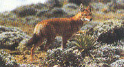
The Semien Fox -despite its name, is more common here in Bale
than it is in Semyen. It is found nowhere in between these two isolated
mountain areas, and nowhere else in the world. The animal is the size and
colour of a European Red Fox, but with long legs, longer muzzle, and a
striking black and white tail. The male and female are similar in
appearance. Semien Fox feed on rodents, and as a result are mainly found
at the higher altitudes where rodents abound. The Sanetti Plateau is an
especially good area to see them, but they do occur in higher parts of the
mountains, as well as down at Gaysay on rare occasions. They are usually
seen hunting alone, but can be seen in pairs, and after the breeding
season as many as eight adults and cubs have been seen together. The
Semien Fox hunts their prey by standing still over the rodent holes,
patiently listening, turning their head and ears from side to side, and
suddenly pouncing when a rat emerges. They will also dig to reach rats on
occasions. They give a high yelping bark. To keep contact with other
foxes, and when apprehensive about anything such as your close proximity.
They are well camouflaged amongst the lichen - covered rocks of the
plateau and can be very hard to see, despite their striking orange-red
colour.
There are more than twenty other small to large-sized mammals to be seen
in the Park. Some are sighted only rarely or are known by the evidence
they leave -such as droppings and footprints. Menelik's Bushbuck is a
form, or subspecies, of the one commonly found over most of
Africa. It is very
different however, in that the adult male is a jet-black color, and both
sexes are long-haired. Bushbuck are the smallest of the Mountain Nyala
family that also includes the Greater and Lesser Kudu, Eland, Bongo and
Sitatunga. Like these other animals, the bushbuck has spirally twisted
horns and spots and stripes on the coat. However, the horns -found in the
male only - are relatively short. They are relatively easy to see at
Dinsho and Gaysay, and are especially plentiful in the forest and heather
of the Adelay ridge. They are not found on the high plateau however which
is largely devoid of vegetation cover, and have rarely been sighted at
altitudes over 3,400 m.
After the Mountain Nyala, the next most common antelope is the Bohor
Reedbuck. These medium-sized straw-coloured antelope are found in large
numbers in the flat grasslands and swamps round Gaysay mountain. Males are
easily recognized from their forward-pointing hooked horns. Reedbuck are
almost only found in the Gaysay and Adelay grasslands, there being no
suitable long-grass areas higher in the mountains. Grey Duiker are the
smallest antelope in the Park. They occur at Gaysay and in the valleys
with sufficient vegetation cover up to about 3,700 m altitude. They are
usually seen alone, diving into cover. Only the males have the short
straight horns.
Klipspringer are only found where there is suitable rocky habitat, mainly
at higher elevations, though a few are found on the very top of Gaysay
mountain. They are especially common in the Lava Flows area. Their unusual
spiky fur and square hooves are adaptations to their agile existence
amongst the rocks and cliffs. They probably derive their Amharic name of "Saas"
from their strange sneezing alarm call. Warthog are reasonably common in
the Gaysay grasslands and forest patches and on Adelay ridge. Groups with
large numbers of piglets are frequently seen in the dry and early wet
seasons. Warthog are not found at higher altitudes in the mountains.
Bushpig and Giant Forest Hog occur in the southern Harenna forest area,
but are rarely seen.
The Rock Hyrax are found in the same cliff and rocky habitat as the
Klipspringer in large numbers at all altitudes. These small dark-coloured
and tailless relatives of the elephant are very numerous in some
localities. They are extremely agile in leaping up and down rock crevices
and their shrill calls echo from the cliffs in the evenings and early
mornings.
Rodents
Rats, mice, etc, are not usually considered "wildlife" by most visitors!
However, in the Bale Mountains they are an extremely important part of the
ecosystem. This is because of the role that several species play in
modifying the soil and vegetation at the higher altitudes, and as the
Semien Fox's source of food. Most parts of the Sanetti Plateau look as
though they have been ploughed recently all the soil freshly turned and
exposed, and tunnelled with numerous holes. This is entirely the work of
the hordes of rodents, several species of which are endemic to the Bale
Mountains, or the high mountain areas of Ethiopia. Their squeaks are heard
easily as you pass through the area, and numbers of them can be seen on
sunny days rushing for their holes as you approach. Of special interest is
the Giant Molerat, a large species that feeds above ground in the daylight
and makes large craterlike depressions. It only partly emerges from these
holes as it feeds the edges. Later it blocks the entrance with soil and
vegetation, and then digs to a new crater nearby to feed there. These
large numbers of rodents support not only the healthy Semien Fox
population in the high plateau area, but also numerous birds of prey,
especially European migrants in the dry season, that pass the European
winter in the Bale Mountains.
Monkeys
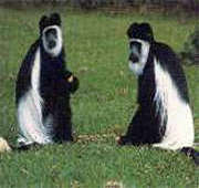
Only three primate species have been found in the
Bale Mountains National
Park so far. The Guereza, or black and white Colobus Monkey, is common
wherever there is suitable forest habitat. Several troops are on the
flanks of Gaysay Mountain and the Adelay ridge, and they are very common
in the Harenna forest area. They are not found in the high mountain area
however, since this is above the forest zone. The Olive Baboon is also
found in large numbers in the Harenna forest, and troops also occur on
Gaysay and Adelay. Surprisingly one troop exists in the high mountain area
in the Lava Flows at over 3,700 m altitude. The small Grivet Monkey is
found only in the Harenna forest at altitudes lower than 3,000 m. They are
sometimes seen from the Goba to Dolo Mena road as you drive through.
Carnivores
There are several other carnivores you are likely to see apart from the
Semien Fox in the
Bale
Mountains
National Park.
The Gaysay grasslands and Dinsho Hill are good places to see the beautiful
Serval Cat. These small, spotted, long-Iegged and short-tailed cats hunt
alone in long grass, depending on rats and small birds as food. Also at
Gaysay you often see the long, lithe shape of the Egyptian mongoose. They
occur in small family parties of up to four or five animals, and like to
use the vehicle tracks as pathways. A close relative -the White-tailed
Mongoose -is nocturnal and may appear in your car headlights when driving
at night.
Spotted Hyena are found at all altitudes in the Park, but in low numbers,
and are rarely seen by day except in the early morning. Their calls
punctuate the night near most villages.
The Golden Jackal however though usually nocturnal, has often been seen by
day in the Gaysay and Dinsho areas. Other carnivores that are rarely seen
but are known to exist in the area are Leopard, Lion, Civet and the little
striped Zorilla.
Birdlife
The Bale Mountains possess many habitats rich in birds,
particularly the
Harenna
Forest
which has been little studied. More than one hundred and sixty species of
birds are known from the Park area, but their number is certain to be
added to considerably in the future. Since the Bale Mountains are isolated
from other similar habitats in Africa by low and dry areas, many endemic
species are found. At least twenty-three species of birds are known to be
endemic to Ethiopia.
No less than fourteen of these species are known to occur in the Bale
Mountains National Park area, and several are easily seen every day.
Amongst the endemics, the more commonly seen only are mentioned here. The
Blue-winged Goose and Rouget's Rail are found near any water be it stream
or high mountain lake, at all altitudes. The noisy Wattled Ibis occurs in
most muddy places busily probing for food with its long curved bill. Large
numbers roost on high, cliffs in the mountains every night. The beautiful
Spot-breasted Plover is found in large numbers in the wet season on the
Sanetti Plateau, and large flocks of the White-collared Pigeon feed on the
ground here at the same period. The weird-Iooking Thick-billed Raven is a
denizen of most villages, and usually finds your camp at any altitude. The
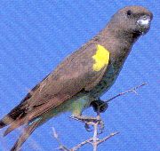
colourful little green and red Black-winged Love-birds are seen in large
numbers in the forest areas, while the larger Yellow-fronted Parrot is
less often seen in the same habitat. The strident ringing calls of the shy
Abyssinian Catbird betray its presence in forest. Close observation in the
Gaysay grasslands and beside the main road will reveal the Abyssinian Long
claw -a drab little bird, but with a smart yellow bib. The high plateau is
characterized by large flocks of the little black and yellow Black-headed
Siskin.
The Bale Mountains, rich
in streams and little Alpine lakes, provide food and security for unusual
water birds such as the Ruddy Shelduck and the tall elegant Wattled Crane.
Many European ducks and waders pass the dry season in the mountains,
before returning to Europe, as do several birds of prey such as the Steppe
Eagle and Kestrel. Probably the most common and friendly bird at all
altitudes is the little drab but cheery Mountain Chat - puffed up like a
round feathered ball in the icy dawn, hopping from tussock to tussock as
he investigates you. One of the largest and most spectacular birds is the
Lammergeier also called the Bearded Vulture or Bone-breaker. This enormous
bird with its over-two-metre wingspan is often seen soaring alone over
suitably high cliffs and rock outcrops, while splintered bone fragments,
even on the top of Tullu Deemtu and
Mt.
Batu
tell of its presence. Wherever you go in Bale there are birds to watch,
and generally unusual ones to add considerably to your experience of this
wonderful area.
Park Attraction
Driving The Park is mainly a walking area since it is a mountainous and
fragile environment. There are few roads, and these require
four-wheel-drive vehicles.
Gaysay
This area derives its name from the little
Gaysay River that flows
into the Web near Dinsho. It consists of Boditi peak at the southern end
of the Lajo Spur, and the flatlands each side of the Gaysay River at the
mountain's base. The main road crosses part of the Gaysay area, just
before reaching Dinsho. The entrance gate lies beside (north of) the main
road seven kilometers before the village, coming from Shashamenne. A small
track from the gate leads you across the Gaysay River and then divides at
the base of the mountain. The eastern arm affords good views of the plains
west of the Web River and goes for four kilometres to the northern
boundary fence at the small Albabo stream. Colobus monkey are often seen
in the Hagenia forest before the first stream crossing. There is a small
photographic hide that is ten minutes walk up the first stream through
lovely Hagenia trees. The left fork of the track goes for three kilometres
to the northern boundary fence around the west flank of Boditi. There are
good views of the Gaysay valley and its associated marshes brimming with
reedbuck. Fine views can be had to the north of the Gaysay valley and Lajo
Spur.
The Gaysay area guarantees every visitor views of the endemic Mountain
Nyala in considerable numbers. As many as 400 have been seen here in a
single afternoon. In addition there are numerous Grey Duiker, Warthog and
the Menelik's race of Bushbuck with beautiful jet-black males.
Colobus and Baboon are sometimes seen here and the beautiful Serval Cat is
often surprised hunting in the long grass. On very rare occasions Leopard
are sighted, and sometimes a pair of the endemic Semien Fox. Birds abound,
especially in the forested parts, and are usually heard if not seen.
Gaysay provides a good morning's or afternoon's wildlife watching and
should on no account be missed by any visitor to the Bale Mountains.
Sanetti Plateau
The spectacular road from Goba south to Dolo-Mena crosses the eastern part
of the Bale Mountains
National Park and the Sanetti Plateau. This, the highest all-weather road
in Africa, crosses the 4,000 m contour, and some of the loveliest
mountain scenery in
Africa that can be viewed from the comfort of your vehicle.
The road climbs up from Goba through beautiful Juniper and Hagenia forest.
The road is lined with the orange-blossomed Leonotis, and in the wet
season the "Red Hot Poker" (Kniphofia} is blooming beneath the trees and
attracting the brilliant iridescent Tacazze and Malachite Sunbirds. This
forest gives way to giant
St John's
Wort (Hypericum revolutum} woods at 3,300 m altitude. This narrow zone is
soon succeeded by heather (Erica} moorlands at 3,400 m and you are out of
the forest and into the open in the mountains proper. Vistas open to the
strange pinnacles of Chorchora peak on the left -one of the Park boundary
markers, and across the sheer-sided Tegona River gorge to the right.
Another steep zigzag climb across slopes covered in heather bushes and
Alchemilla johnstoni scrub, and you enter the Plateau proper, through the
portals of the weird five-metre tall flower columns of giant Lobelia
rynchopetalum plants. Here the plateau is studded with numerous shallow
alpine lakes, with views to the steep-sided volcanic plug of Konteh Tullu
in the south, and the long craggy ridges of Mt. Batu (4,203 m) in the
west.
The road continues climbing gently, part Crane lakes at the base of Konteh.
This is the centre of the best area for seeing Semien Fox, and on rare
occasions small groups of Mountain Nyala. Here, you are at over 4,000 m
above sea level, and in pure, clear cool mountain air with views in all
directions on a clear day. These views are heightened by the steep climb
to the top of Konteh (4,132 m), or the longer (one and a half hour) climb
to the top of domed Tullu Deemtu (the "red mountain" in Oromo) to the west
of the road soon after. This is the second highest mountain in Ethiopia at
4,377 m above sea level.
The road then skirts the base of Tullu Deemtu, and continues south to the
edge of the Harenna escarpment, forty kilometres from Goba. Here, on a
clear day, the view is open right out over the southern lowlands. The road
descends the escarpment through a series of spectacular hairpin bends. The
initial heather scrub gives way after a few kilometres to Hagenia, heather
and St John's Wort forest, and later merges into lush Podocarpus forest;
enormous trees covered in epiphytes mosses, ferns and "Old Man's Beard"
lichens. This continues down the small escarpment of Rira, where looking
back you see the tall rock towers of Gujurule, their tops often shrouded
in cloud and mist. Round their base is glorious mixed forest with bamboo
and many clear sparkling streams that are the source of the Shawe River.
Later the road crosses the main Shawe River, passing through tall mature
Podo forest with its towering trees, until it suddenly ends almost 100
kilometres from Goba.
The Park boundary is shortly before this as you cross the Shisha -a small
tributary of the
Yadot
River.
The forest gives way abruptly to dry, lowland wooded grasslands at about
1,600 m altitude, and about ten kilometres later the little village of
Dolo-Mena is reached. Here on a market day you will be treated to the
surprising sight of camels, so soon after leaving the Alpine conditions of
over 4,000 m altitude.
Dolo-Mena
The village is 110 kilometres from Goba, but a reasonable undertaking for
a day's drive is from Goba to the southern edge of the plateau, with maybe
a descent of the escarpment into the forest below, followed by the return
to Goba. A good campsite exists at Katcha, after Rira on the left of the
road, along a track to a road quarry. This is a good base for walking in
the bamboo forest, and, for the more energetic, exploring the Gujurule
volcanic plugs.
Simbirro Track
This is a rough (four-wheel-drive only) eleven kilometers track leading
from the Park Headquarters compound, south into the Park area. This track
crosses the interesting natural bridge over the Danka River where hyrax
can be seen. It then runs beneath cliffs through heather to the edge of
the gorge of the Web River. It ends in a broad flat valley, from where it
is an easy forty minute walk to the beautiful Finch'Abera waterfall, where
the Web and Wolla Rivers join. If you are lucky you may see Semien Fox in
the area at the end of the track. Arrangements can be made to meet your
horses at this point for more ambitious treks into the main peak area of
the Park.
Walking
Bale Mountains National Park is essentially a walking area. Horse treks of
several days duration into the main peak area with pack and riding horses
and accompanied by a guide, can be arranged through the Park authorities
in Dinsho. In addition, shorter walks can be accomplished in the Dinsho
area, or from anywhere along the roads and tracks mentioned above.
At Dinsho Headquarters a one kilometre Nature Trail has been designed up
Dinsho Hill. This gives a brief introduction to the plants and animals of
the area, and the location of the main Park. There is the added
opportunity of seeing Mountain Nyala at close quarters on foot, in the
Sanctuary afforded by the fence around the compound. From the top of the
hill (3,240 m) good views on a clear day in all directions help in
understanding the layout of the Park.
Walking on Gaysay hill is rewarding in terms of the views and the chances
of seeing wildlife at close quarters. The physically fit will find the
steep climb to the Boditi summit (3,520 m) worthwhile for a spectacular
view of the Gaysay River flats and south into the main Park area.
A very enjoyable day-Iong walk can be had from Dinsho, up the Web valley
to Gasuray peak (3,325 m). The steep Climb to the summit is through
beautiful mature Hagenia and juniper forest, and into heather at the top.
A traverse of the uplands to the north along the connecting spur to the
Adelay ridge leads you through beautiful heather and grass glades with the
strange grey tussocks of Helichrysum citrispinum -one of the "everlasting
flowers". Mountain nyala, Klipspringer. Menelik's Bushbuck and Warthog are
commonly encountered here. A steep descent off the northeast corner of
Adelay brings you back down to the main road and Dinsho village.
The Sanetti Plateau is crowned by several peaks that add a good walk to
the drive over it. Konteh Tullu - the striking volcanic plug east of the
road on the plateau, may look formidable, but twenty minutes of steep
scrambling from its base gives you magnificent views from the top (4, 132
m) in all directions. Tullu Deemtu is the second highest mountain in
Ethiopia at 4,377 m, and the highest point in the
Bale
Mountains.
Starting from the main road at its base it takes one and a half to two
hours to climb the slopes and reach the summit - a rounded ridge hidden
from the aspect of your starting point. Hares and rodents abound up here,
despite the sparse vegetation cover. Mountain Nyala are often seen below
the summit to the south where there is a small water seepage point and
grove of Giant Lobelia plants. Wide views can be had all around, but
especially to the main plateau with its lakes and lava flows to the west,
and to Mt.
Batu
a short distance north.
Mount
Batu
Is a longer walking prospect, but can be done in a long day from the
plateau road. The mountain is a long horseshoe-shaped ridge at the head of
the great Shiya and
Tegona
River
gorges. It is very craggy and more rugged than Tullu Deemtu in appearance,
and seemingly more mountainous, for all that it is a few metres lower.
Leopard has been sighted near the top, as have Klipspringer and Mountain
Nyala, while montane birds such as the chough and lammergeier soar
effortlessly over as you climb up the mountain's flanks. It is strongly
recommended that a guide be taken for the climb up Mt. Batu.
Horse trekking
Short riding trips can be arranged in the Dinsho area, but it is far more
worthwhile to set aside at least four full days to enjoy a horse trip to
the full. Arrangements are best made beforehand by letter or phone, but
horses can be organized for a morning departure if requested the afternoon
before. Various routes can be followed, and it is best to take the advice
of your local guide from Dinsho.
Other
Attractions
Sof Omar Caves
The fantastic limestone caves of Sof Omar make a day's outing from Dinsho,
Robe or Goba. The road leaves Robe town, crossing the farming areas to the
east, before descending into the lowlands. Here the vegetation is very
different being dry lowland with wooded grasslands. The caves lie at 1,300
m above sea level. This is in marked contrast to what you will experience
in the Bale Mountains at up to 4,000 m. Very different animals occur along
the way as well, most noticeably the Greater and Lesser Kudu - both
relatives of the Mountain Nyala, and the tiny dik dik antelope. The caves
themselves carry the whole flow of the
Web
River
that rises in the Bale Mountains, underground through wonderfully carved
caverns for a distance of one and a half kilometres. There are over
fifteen kilometres of associated passages, which require skill, time and
special equipment for a full exploration. However, a friendly local guide
will show you enough to take your breath away and make the trip
worthwhile, for an hour or for as long as you care to spend. A cool dip in
the clear River afterwards refreshes you for the return drive. Full
details of the caves are provided in the booklet, "The Caves of Sof Omar"
obtainable from the Ethiopian Tourism Commission.
Fishing
Nine Rivers and streams between Adaba and Goba were stocked with trout in
the early 1970' s. These have thrived and are now available for sport
fishing. Information, guides and permits can be obtained from the Ministry
of Agriculture offices in Adaba, Dinsho and Goba.Brown Trout can be fished
on a short stretch of the Web River near Dinsho, while all the other
Rivers are stocked with Rainbow. Anglers have to provide all their own
equipment. Fishing conditions are varied - cascading waterfalls, deep
still pools, or the tiny narrow and clear Danka stream. Good exercise,
beautiful scenery, peaceful surroundings, are all combined in the one
activity.
Access
Dinsho -the Park Headquarters, Robe and Goba can all be reached in a long
day's drive from
Addis Ababa.
There are two routes -either along the Rift Valley south to Shashamenne,
or through Asella. The route via Shashamenne has more tarmac, and provides
the added attractions of the Rift Valley Lakes National Park - Abiatta and
Shala lakes, and the Senkelle Swayne's Hartebeest Sanctuary, as well as
the opportunity for an overnight stop at Lake Langano Resort.
From Shashamenne you take the road east onto the wheat-growing plateau,
before climbing up into the mountains from Adaba through the beautiful
Zuten Melka Gorge.
The Asella route takes you south from Nazaret across the Awash River and
along the eastern wall of the Rift Valley, below the
Arsi
Mountains,
which are to the east. Once over the pass between Mts. Kakka and Nkolo,
you descend to cross the Wabe Shebele River, before reaching Dodola and
joining the route into the mountains from Shashamenne.
Equipments
Warm clothing is a must at any time of the year, and waterproof clothing
essential between March and November, and advisable at all times. Visitors
who are intending to do some walking will need sturdy shoes or boots. It
must be remembered that the sun at high altitudes burns the skin easily.
Hats, dark glasses and sunscreen lotions are therefore strongly
recommended. Those visitors spending nights on the trail need warm
sleeping bags and light tents and camping equipment. These can be provided
by NTO for those trips arranged through them. Useful companions on a trip
to the Bale Mountains National Park are "Endemic Mammals of Ethiopia",
"Ethiopia's Endemic Birds" and the "Caves of Sof Omar" which are all
published by ETC and available from NTO and bookshops in Addis. Also very
useful is "Some Wild Flowering Plants of Ethiopia" by Sue Edwards.
Permits
Travel permits must be obtained in
Addis Ababa. They are
currently $8 for 48 hours. These are arranged by NTO for their clients,
but otherwise must be obtained by individuals themselves. Daily tickets
for the Park are obtained and paid for at the Park Headquarters in Dinsho.
Fishermen will also need a fishing permit, which is obtained from the
Fisheries Department in Addis Ababa, or from Ministry of Agriculture
offices in Addis Ababa,
Dinsho or Goba.
Accommodation
Accommodation is not yet available in the Park area. The new Ras Hotel at
Goba provides good accommodation fifty kilometres from Park Headquarters
at Dinsho, and is at the base of the road leading to the Sanetti plateau
and the east and Southern parts of the Park. The Bekelle Mola Hotel at
Robe, (15 km north of Goba) provides motel type accommodation, forty
kilometres from Dinsho on the way to Goba. Under certain circumstances
camping may be allowed at the Park Headquarters. Obviously camping is
allowed in the main part of the Park when visitors are horse trekking.
Contact Address
The Park Warden
Bale Mountains National Parks
C/o Dinsho Postal agent
Dinsho, Bale Region
Tel: Disho 8
Ethiopia Tourism commission
P.O. Box
2183
Tel.
5514838/5512923
Fax: 251-1-5513899
Addis Ababa,
Ethiopia
Email:
info@tourismethiopia.org or
tour-com@telecom.net.et
|
